Caitlin is a Senior Project Manager at Sonoma Ecology Center.
This January, it became official that 650 acres of the Sonoma Developmental Center (SDC) has been transferred to California State Parks. For decades, Sonoma Ecology Center has advocated for a vision for the SDC campus that protects the incredible array of species that live there, as well as housing for the region and an economic engine on the campus. But what exactly does this transfer mean? We sat down with Caitlin Cornwall, our Senior Project Manager, to understand what’s in store for the future of SDC after this decision.
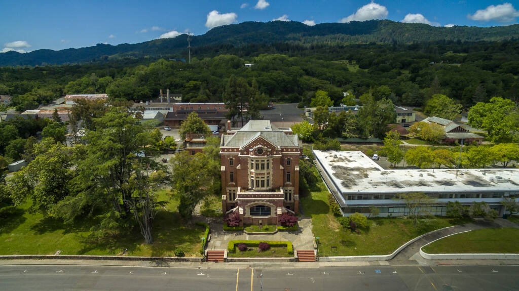
Sonoma Developmental Center’s main entrance. Photo courtesy of Chad Surmick/The Press Democrat.
Can you tell us about this land transfer, and what it means for SDC and the nearby region? Why should we care about it?
At least 650 acres of some of the most varied, beautiful land in the North Bay, owned by the people of the state of California, and long a part of Sonoma Developmental Center (SDC), have been transferred to California State Parks’ ownership and management. This means that these acres are protected forever from being converted into buildings or roads or farms, that the public will forever have access to walk in their beauty, and they will be managed for wildlife, water, recreation, and learning.
The land includes deep dark redwood forests, stunning vistas of gentle grassy hills studded with massive oaks, several streams both seasonal and year-round including a Sonoma Creek section that routinely hosts a family of beaver and endangered freshwater shrimp, precious water bodies including two lakes and a large swampy spring, the burned remains of a dairy with multiple buildings, former horse pastures, and Sonoma Valley’s largest remaining freshwater wetland. It is a wildlife connection of local significance, allowing animals like mountain lions and foxes to cross between Sonoma Mountain and the Mayacamas Mountains, and of statewide significance, linking Point Reyes to the Blue Ridge-Berryessa region.
Since 2019, this land transfer to State Parks has been promised by the legislation governing the future of the SDC. Only now that transfer is complete does SEC feel secure that those acres are truly safe. Note that the 180-acre former SDC campus is not part of the new park.
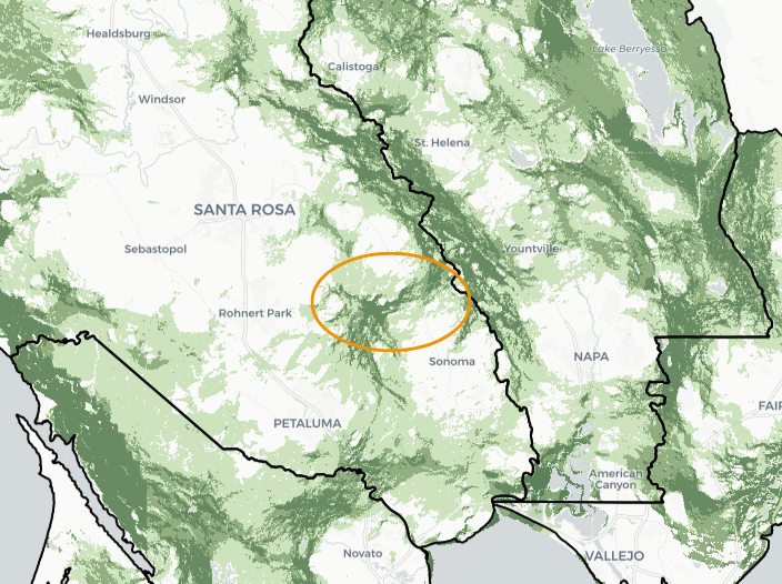
A screenshot from Conservation Lands Network’s Explorer Tool, showing their “Regional Connectivity” layer. The orange oval shows the Sonoma Valley Wildlife Corridor, the center part of which is SDC land. The dark green block in the lower left is Point Reyes National Seashore and west Marin County; dark green areas in the upper right are part of Blue Ridge-Berryessa National Monument.
What can we expect from this land transfer?
Many people expect the new acreage will be added to the adjacent Jack London State Historic Park, which is managed by the nonprofit Jack London Park Partners. Already, State Parks has hired two Environmental Specialists who will work exclusively on the new acreage, along with a ranger/patroller. Eventually, we anticipate the open space will be managed on the western side by Jack London Park Partners, and on the eastern side by Sonoma County Regional Parks, the agency that owns and operates the adjacent Sonoma Valley Regional Park.
Across the state and at local parks, State Parks is using beneficial fire more frequently as a land management tool, which SEC supports. State Parks is already preparing for prescribed burns in the new acreage, by removing Douglas fir trees that have grown up in oak woodlands and mixed hardwood forests downslope from Fern Lake.
Who are the people who have advocated for this transfer of land?
SEC has been central to protecting SDC’s open space for over 25 years.
Long before SDC’s 2019 closure was hinted at, SEC worked with local and state agencies to explore the concept of a wildlife corridor across Sonoma Valley, connecting its mountains through SDC’s public lands. SEC then worked with state representatives, Sonoma Mountain Preservation, and others, to see 300 acres along SDC’s Sonoma Mountain hilltop protected, and in 2002 to see that piece and 300 additional acres added permanently to Jack London State Historic Park.
Ever since SDC’s closure became a sure thing, around 2017, SEC favored putting most of SDC’s acreage into a permanently protected legal status. When it became clear in 2019 that the campus would eventually be redeveloped, SEC’s efforts became more urgent in advocating that the open space areas be legally protected as soon as possible, not waiting until plans for the 180-acre SDC campus were final.
SEC was a founding member of the SDC coalition formed by Sonoma County Supervisor Susan Gorin, hosting meetings for years at our offices on the SDC campus where many nonprofits and government agencies and representatives partnered to bring about the best outcomes. Our partners in these efforts are largely still working with us today: Sonoma Land Trust, Sonoma County Ag + Open Space, Sonoma Mountain Preservation, Sonoma County Regional Parks, the offices of State Senators Mike McGuire and Bill Dodd.
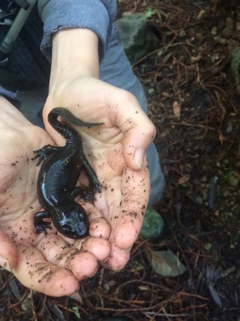
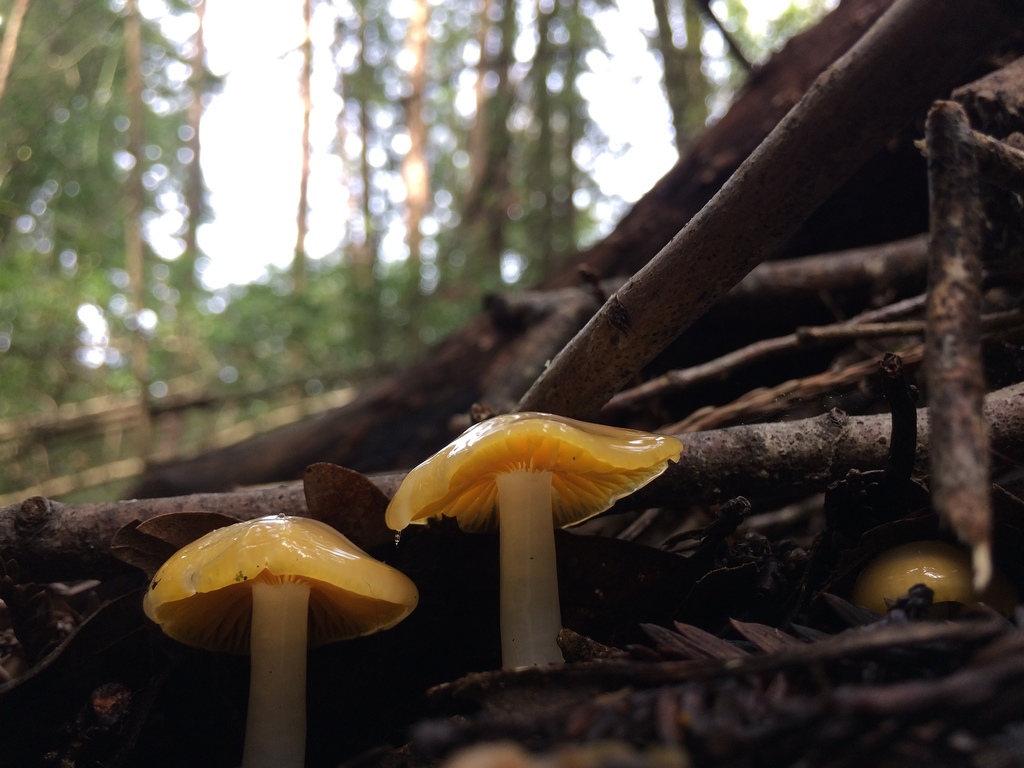
Left: A Giant California Salamander, considered a species of special concern. Right: The endangered Golden-gilled Waxy Cap. These species were seen at the Sonoma Developmental Center campus and their photos were uploaded by Dr. Dan Levitis on the iNaturalist platform and verified by experts.
This seems like a win. Are there some areas that our organization is still concerned about?
State Parks announced that 650 acres of the SDC property will now come under its management, but there are actually 700-750 acres of undeveloped land on the SDC property, depending on your definition. For example, the old dairy area on the valley floor east of the campus burned completely in the 2017 fires but its foundations are still there. A water treatment plant is still there but it may eventually be razed or replaced. A wide strip along the north edge of the campus has buildings in it but should become part of the wildlife corridor.
The map below shows boundaries of the State’s interdepartmental transfer to State Parks. The large red area is the SDC campus, but with its original larger size, not shrunk inward on the northern side as is necessary to widen this narrowest part of the wildlife corridor.
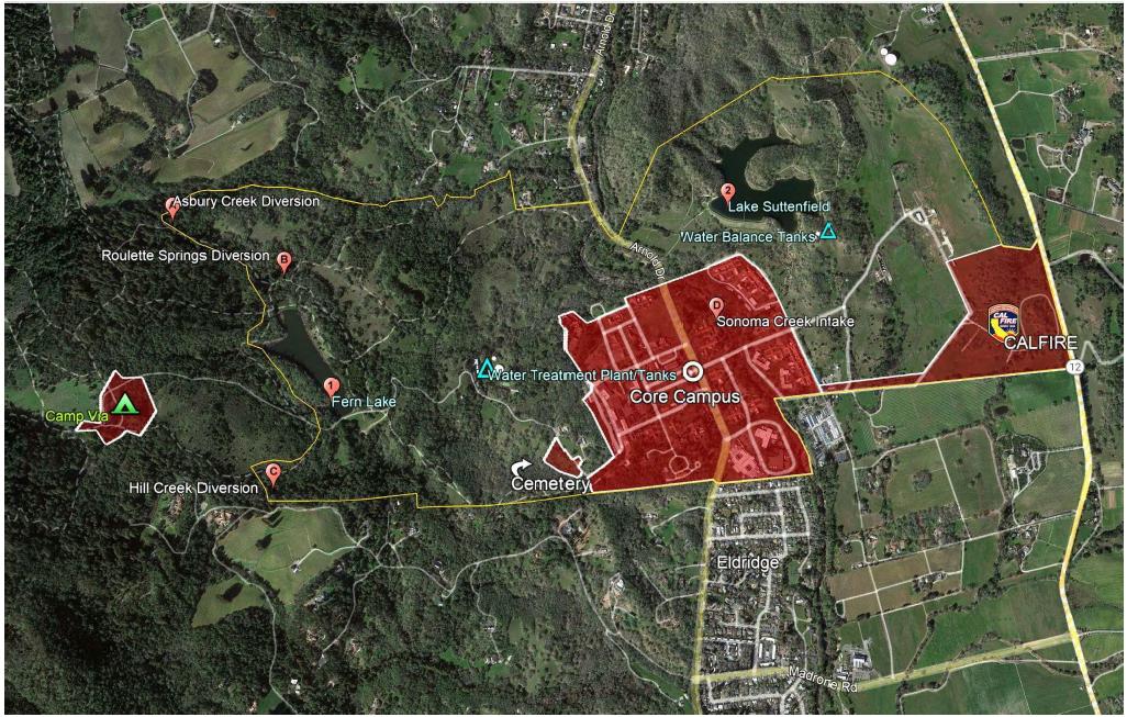
SEC is carefully tracking the fate of the 100-150 acres that the State is not clear about.
- Unfortunately, one piece of land has apparently already been removed from the new park’s open space: over 50 acres along Highway 12 was legislatively transferred to CAL FIRE sometime in January, apparently for offices. The public was not informed that this was a possibility. SEC and others closely involved in SDC were taken by surprise. Buildings, lights, and pavement in this location would run counter to the “permanent protection of the open space and natural resources” described in the legislation that created the SDC Specific Plan and protected its open space lands. SEC would like to see this carve-out rescinded. CAL FIRE is a valued member of our community and there is room on the SDC campus and at Sonoma County’s Los Guilicos site for offices or other uses that have been proposed over the years by CAL FIRE such as a training camp.
- The above map shows in red a strip of land in the eastern open space area, along the southern boundary of the property with Will Bucklin’s Old Hill vineyard, where there is pressure to build a road through the oak woodland and across streams that would connect the campus to Highway 12. The SDC Specific Plan leaves open the possibility of this road getting built. SEC’s project to uncover SDC’s biodiversity has observed sensitive animals like the Western pond turtles in this area. And again, building a road is contrary to open space protection. SEC only supports a road here if it is dirt or gravel (not paved), narrow, unlit, and only used for emergencies.
- Camp Via, the former overnight education and recreation complex on the flank of Sonoma Mountain, next to the historic orchard, is also shown on this map as not yet included in the State Parks transfer, although SEC’s understanding is that this complex will eventually become part of the State Park. We generally support this, as long as the road is not opened to general-use vehicle traffic.
- SDC’s old water treatment plant, surrounded by open space on the hillside well above the campus, is also shown on this map as not yet part of the new parkland. SEC favors the decommissioning of this facility and adding its site to the protected open space, unless there is a good reason to build something there that could dramatically reduce the energy or water use of the redeveloped campus, such as a pumped hydro energy system.
- It’s essential for the functioning of the wildlife corridor that its narrowest portion be enlarged, not shrunk. The entire northern border between the redeveloped campus and the new park needs to be further south than it was when SDC was operating. From the Specific Plan and the recent land transfer, it’s still not clear whether this has happened.
What is SEC still hoping to see accomplished at the Sonoma Developmental Center as more details get hashed out?
In addition to maximizing the area of protected open space, SEC is also working with State Parks and legislators on how that acreage is managed. We want to see multiple benefits for the public, including some that may be beyond traditional State Parks priorities. SEC hopes to see:
- A park trail system that does the least harm to wildlife, especially shy animals like mountain lions and porcupines. Trails should be absent from the narrowest part of the wildlife corridor (the northern part of the property). Trailheads with their parking lots, pavement, lighting, dogs, and people should not be placed at the edge of the narrowest part of the wildlife corridor, but inside the campus.
- Trails that minimize stream crossings and steep slopes, so that soil erosion doesn’t foul the streams.
- Ongoing land stewardship to minimize the presence of invasive plant and animal species, reduce the severity of inevitable future wildfires, and optimize the diversity and abundance of native, climate-resilient plant communities.
- Proactive repair and enhancement of the land’s ability to catch and infiltrate water. Rain and runoff are precious resources. SDC’s lands are especially water-rich, but over time features like ditches, culverts, and roads have made water run off the land before it can sink it. Reversing these changes will make the land more resilient to climate change, and allow its plants and animals to thrive with secure water supplies through the summer. Sinking more water can also recharge groundwater, to the benefit of Sonoma Creek and the many living things that depend on it, and Sonoma Valley groundwater users south of the site.
In your view, what’s in the future for SDC?
For several years, State Parks will manage their new acreage under “interim management,” without an overall “general” plan. Luckily, some actions like prescribed burns and fuels management can proceed without a general plan. But others, like re-routing trails that are badly eroding or right in the wildlife corridor, will be hard for California State Parks to do without outside encouragement.
The name of the area now officially under State Parks management, and the rules that guide land management priorities, won’t be decided for several years. These decisions are made by the California Park and Recreation Commission. They will decide on a name and “unit classification” for the new acreage. This matters because if the acreage is all given a “historic” classification, like at Jack London Historic State Park, certain beneficial stewardship activities may be very difficult to do. For example, SEC would like to see more water retained on the land, by reshaping old ditches or installing beaver dam analogs. We would also like the redeveloped campus to produce and recycle its own water and energy, which could require use of small areas of land outside the main campus. At this time, SEC believes it may be best for the combined park acreage to be designated as a state park, not a state historic park, with only the historic portions of today’s Jack London Historic State Park designated as a historic or cultural preserve.
Meanwhile, the process for the campus redevelopment continues to be slow, opaque, and controversial. The lawsuit suing the project’s EIR has a major milestone, possibly a decision, in March. In early March, the developer team is expected to submit to Sonoma County a detailed project proposal that SEC and many others will examine closely and attempt to improve. SEC continues to be in favor of:
- many design rules still in force in the Specific Plan that SEC argued for, such as bigger setbacks from streams and down-cast lighting
- housing that is more compact, taller, and more affordable than what’s in the Specific Plan or the previous developer’s proposal
- no hotel or a compact hotel away from the wildlife corridor
- services like on-site childcare and elder care so residents drive less
- an emphasis on transit
Learn more about SEC’s vision for SDC here.
What can our audience, who cares about the future of SDC, do to stay involved in the decision making process?
First, tell your elected representatives to do better, in your own words. Thank them for the new park acreage, and tell them you want them to rescind the transfer of the eastern open space area to CAL FIRE, not give away any more of SDC’s open space, assure that the campus boundary is shrunk along the entire northern border to widen the wildlife corridor, keep trails and other features out of the wildlife corridor, and make land management decisions in public, not in secret.
- Call Senator Mike McGuire at 707.576.2771 or email him here.
- Call Senator Bill Dodd at 707.224.1990 or email him here.
- Call Assemblymember Cecilia Aguiar-Curry at 707.224.0440 or email her here.
- Assemblymember Damon Connolly is 707.576.2631 or email him here.
Next, you can protect the wildlife corridor by making observations of organisms on your phone, in the iNaturalist app. California State Parks can only justify excluding recreational uses from areas based on data showing that sensitive species occur there. Focus on the northern parts of the whole property (the Carolyn Day trail, the area between the two Arnold Drive bridges) and along the southeast border (from Sonoma Creek to Highway 12).
