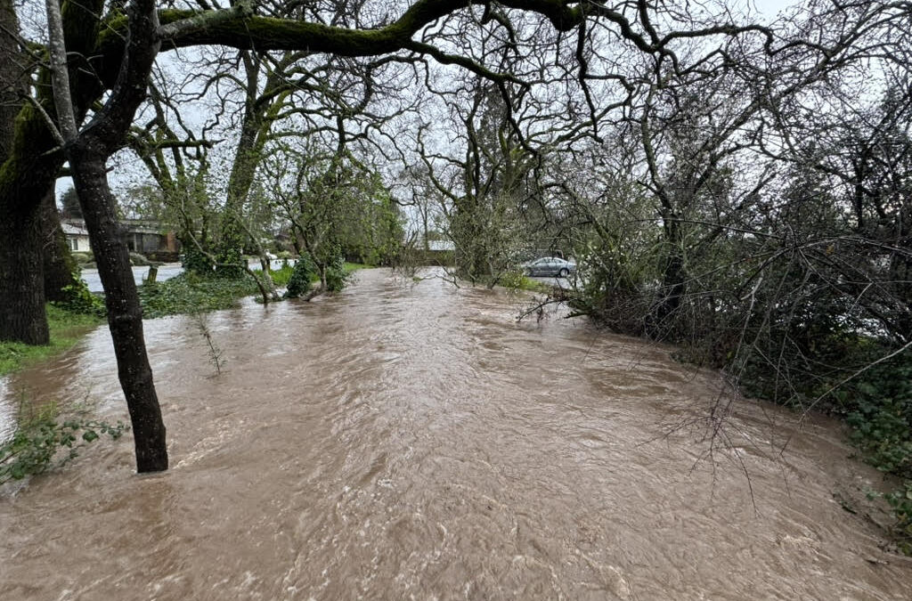
A powerful storm flooded Sonoma this past Tuesday, February 4, 2025, following another atmospheric river event over the weekend. 2.75 inches of rain fell on Tuesday in Sonoma, adding to the prior evening’s rain for a storm total of 3.15 inches. The atmospheric river over the weekend also brought in 3 inches of rain, ending a month-long dry spell. Most of Tuesday’s rain fell near the end of these storms, creating runoff that overwhelmed smaller streams that are quick to rise and fall, like Nathanson and Fryer creeks running through Sonoma.
“Much of Sonoma is a former wetland, gently sloping to the south, that was drained for development,” says Richard Dale, Executive Director of Sonoma Ecology Center. “As land in town and upstream was and is developed, water increasingly has nowhere to go.”
In Tuesday’s storm, water spread around town, especially along the plaza, where Fryer Creek ran out of its culvert down 1st Street West, closing that side of the Plaza, and throughout streets in east Sonoma, where Nathanson Creek topped its banks and ran northeast to south along the streets. Several Plaza business were impacted along 1st Street West. Napa Street was closed between 4th Street East and 2nd Street East, and like several other streets, there was a single lane between the Plaza and 2nd Street West. East MacArthur Street and other streets on the east side of Sonoma had water running several feet out from one or both road shoulders.

Photo by Richard Dale
Sonoma Creek flow peaked Tuesday at 8870 cubic feet per second (cfs), according to its stream gage, at 4:30 pm. This flow was equivalent to the November storm of 2024, after nearly 10 inches of rainfall, ending a long, dry summer season.
Nathanson Creek flow peaked Tuesday between 2:30-5:00 pm during the heaviest rains, with its stream gage continually reporting 7.5 feet above its bed. The gage’s reported flow appears to have been adjusted midway through the event, originally showing nearly 800 cfs when it went offline, then showing about 400 cfs when its flow was reported again. Given higher flows were shown in November when less flooding occurred, it seems the flow estimate didn’t account for water running through town that wasn’t in the creek.

Photo by Richard Dale
Sonoma has always been prone to flooding. The City is located here because of its abundant water. Because there is a shallow groundwater table in much of Sonoma, water can’t sink in. Flooding is anticipated to get worse as climate change increases the intensity of rain events and more fires occur, which increase runoff.
The solution to Sonoma’s flooding is to slow water down all along its path, especially along Nathanson Creek, especially above and below the City. New development upstream of the City reduces available land where solutions could happen, such as places where the stream could widen out for a few hours during rainstorms. It also increases the risk of more flooding downstream and raises the cost of future solutions.
As with any system, flooding needs to be considered as part of a whole, with drought, fire, and flooding understood to be related events. Any actions we take are opportunities to address all these issues holistically. Capturing and infiltrating water upstream, in the hills, and on floodplains before the stream gets to town, is part of the solution. Managing vegetation to reduce fire risk, if done thoughtfully (see Tending the Land, a free resource for fire resilience), can be combined with efforts to slow down water, and help get it into the water table. Projects on the floodplain outside of town, as vineyards replant, or shift with a changing economy or climate, may be wise investments. The neighboring Napa River watershed reduced flood risk and created wildlife habitat by allowing floodwaters to spread out downstream of their City; we could do the same for Sonoma’s watershed, over time.
Investments now, even if they seem expensive, could be a lot less expensive than solutions that have to happen in the future when homes and businesses are impacted. And with Sonoma County and City of Sonoma general plans both in progress, thinking about solutions now is another wise investment. Please consider adding your voice to these plans.
Stay informed on how to participate in the general plan process using these links: Sonoma County General Plan Update; City of Sonoma General Plan Update. Sonoma Ecology Center will also reach out as opportunities arise to weigh in on general plan topics. If you haven’t already, be sure to sign up for our email newsletter to stay updated.
")
Photo by Richard Dale