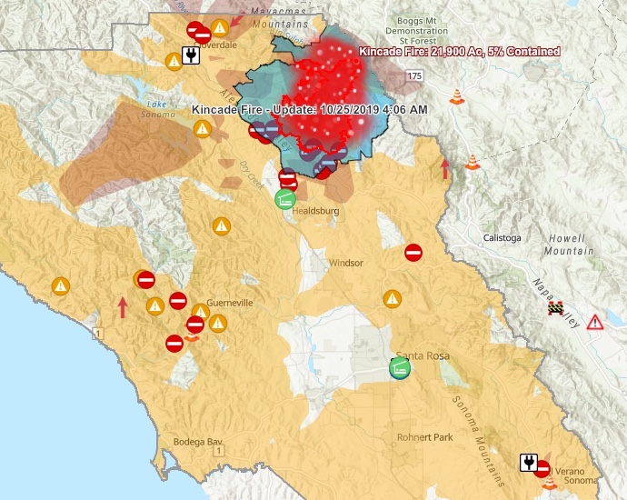
Given the forecasted high winds, planned power outages, and a fire already underway to our north, there is much to keep track of this weekend. Below is a list of links to real-time information intended to help you stay up to date when it comes to fires, weather, power shutoffs and air quality.
Meteorologists predict a major wind event – with gusts as high as 80 miles per hour – for parts of Sonoma County on Saturday night and Sunday. Due to the dryness of our air and vegetation, this can be a dangerous situation and we urge locals to be extremely careful when it comes to potential fire sources (anything from a cigarette butt to a lawnmower can start a conflagration) as well as potential falling objects such as unstable trees or tree limbs.
For its part, PG&E is taking the usual precaution by shutting off power to at least parts of Sonoma Valley. Please make preparations if you think your residence may be affected – and keep in mind that if the power is off on Monday, we are prepared to host pop-up day camps for local kids as needed. (Power is already off at Sugarloaf Ridge State Park, which remains open to the public on Friday although campfires are prohibited. Sugarloaf will be closing Saturday at 6 p.m. and could remain closed through Sunday. To see weather and air conditions at Sugarloaf, go to https://sugarloafpark.org/weather/.)
We’re especially concerned for parts of Sonoma County south of the still-raging Kincade Fire that could be threatened should the wind shift in that direction. To our friends there and throughout Sonoma County and Sonoma Valley: please stay safe!
Emergency Preparedness
- Sonoma County emergency information and preparedness: https://socoemergency.org
- City of Sonoma power shutoff preparedness: https://www.sonomacity.org/extended-power-outages/
Weather and Wind
- National Weather Service forecast (includes weather advisories): https://forecast.weather.gov/MapClick.php?lat=38.291&lon=-122.4652#.XbMq3i3MzJP
- National Weather Service area forecast summary: https://forecast.weather.gov/product.php?site=MTR&issuedby=MTR&product=AFD&format=CI&version=1&glossary=1
- Current wind gusts in North Bay: https://www.sonomanews.com/home/a1/10215505-181/map-current-wind-gusts-in
Wildfires
- CalFire incidents main page: https://www.fire.ca.gov/incidents/
- Sonoma County Incident Map: https://sonomacounty.maps.arcgis.com/apps/webappviewer/index.html?id=2cb4401e1fc0494dbf9d9e22aa794617
Air Quality
- EPA AirNow air quality map: https://www.airnow.gov/index.cfm?action=airnow.local_city&zipcode=95476&submit=Go
- EPA AirNow smoke plume map: https://www.airnow.gov/index.cfm?action=topics.smoke_wildfires
- National Weather Service air quality forecast map: https://airquality.weather.gov/sectors/northcalifornia.php
- PurpleAir air quality map: https://www.purpleair.com/map?module=AQI&conversion=C0&average=10&layer=standard&advanced=false&inside=true&outside=true&mine=true#10.72/38.3161/-122.4486
Power Shutoffs
- Public safety power shutoff area map: https://www.arcgis.com/apps/View/index.html
- PG&E proposed power shutoff lookup by address: https://psps.ss.pge.com
- PG&E power shutoff news and general info page: https://www.pge.com/en_US/safety/emergency-preparedness/natural-disaster/wildfires/public-safety-event.page
- Sonoma Ecology Center power shutoff tips: https://sonomaecologycenter.org/tips-on-dealing-with-the-public-safety-power-shutoff/

