
Water Update from SEC Senior Scientist, Steven Lee
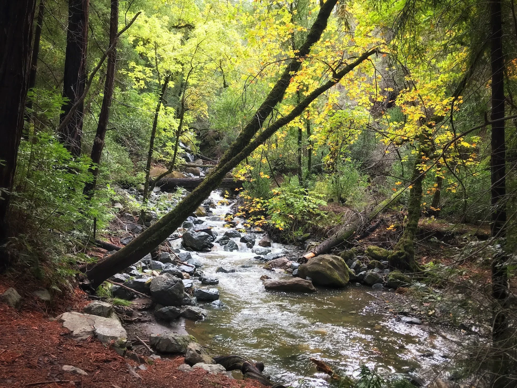
Image courtesy of Kristin Russell
With the start of the new “Water Year,” which began October 1st, it’s timely to reflect on this past year’s rainfall and look ahead to the coming wet season this winter. So what can we learn from this past water year, and what should we watch for in the months ahead with a potentially powerful El Niño on the horizon?

Rain gauge data collected near the Sonoma Valley Wildlife Corridor in the Asbury Creek area, recorded a total of 35.05 inches of rain this water year—below the local average of 42.4 inches. But the amount of rain we receive is only part of the story; when and how intensely it falls can be just as important.
As the figure 1 shows, this water year’s precipitation (thick black line) was relatively well distributed throughout the rainy season, rather than arriving in just a few intense, short-lived storms. Rainfall tracked fairly closely with the daily average (gray dashed line), much as it did during water year 2024.
Figure 1. Timing and Extent of Precipitation in the Last 8 Water Years at Glen Ellen Monitoring Station
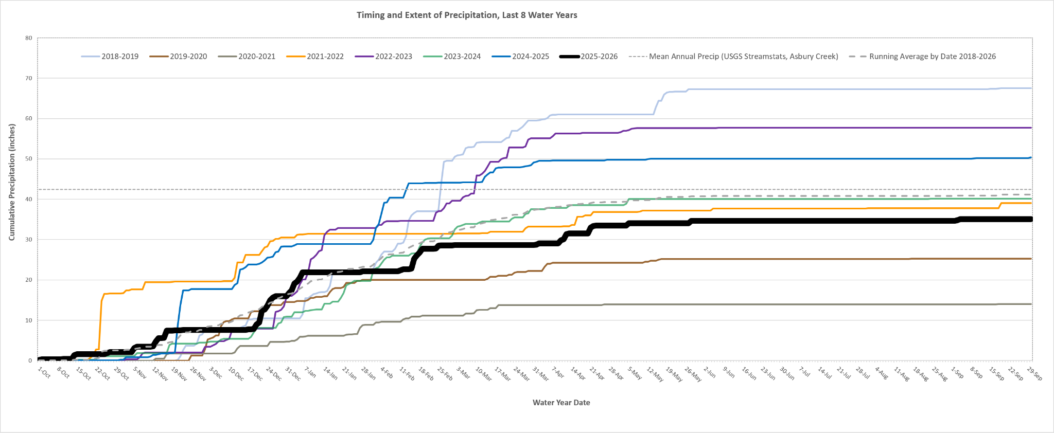
This pattern generally bodes well for stream health. When rainfall is spread well throughout the season, it helps sustain groundwater recharge and supports streamflow in Sonoma Creek and its major tributaries well into the dry months. That's exactly what we saw this year, with perennial flow continuing throughout the mainstem of Sonoma Creek all summer long.
Compare that with water year 2021, when the entire length of Sonoma Creek either dried completely or dwindled to isolated pools, placing stress on steelhead, endangered California freshwater shrimp, and other aquatic species. Of course, the broader context matters, too. Had this year's below-average rainfall followed several consecutive drought years, the watershed might have been in a very different condition.
The news is also encouraging when it comes to our regional water supply. As the second chart illustrates, Lake Sonoma, the county's primary water supply reservoir, remains nearly full at the end of the dry season.
Figure 2. Lake Sonoma Water Storage (source: Sonoma Water)
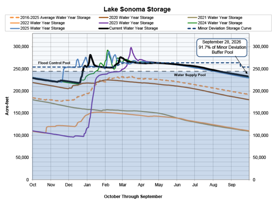
This is in part due to Forecast Informed Reservoir Operations (FIRO), wherein Sonoma Water and the US Army Corps of Engineers were able to maintain excellent water levels in the lake as they worked around the significant storm periods we saw starting in late December and late February. In fact, according to Sonoma Water, the lake level is about a foot higher than it was at this time last year, even though a foot less rainfall fell in the vicinity of the lake.
With the current, yet tenuous, predictions for this major El Niño year, Sonoma Water will likely be able to manage water levels over the upcoming months such that we'll start the upcoming dry season with a completely full Lake Sonoma and have at least a couple years of stable water supply beyond that, even if drought conditions return.
Regarding El Niño, it remains uncertain whether we'll get more precipitation than normal this winter or not. Current forecasts don't point to an especially wet fall in October or November, but suggest there is a possibility of substantially above-average rainfall between December and March—potentially as much as twice our normal precipitation, or more.
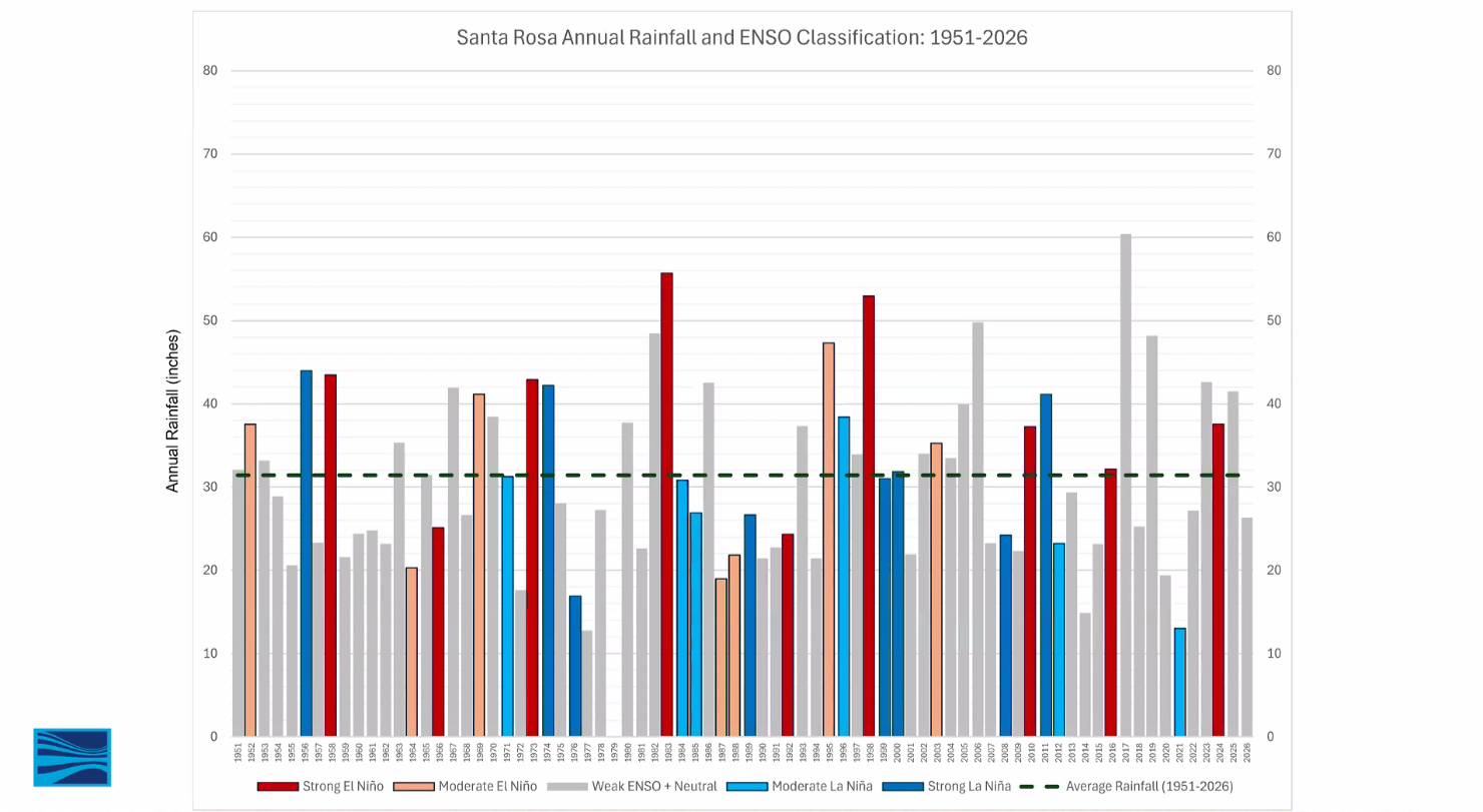
Even a strong El Niño, however, doesn't guarantee a wet winter here in the North Bay. Southern California generally experiences increased rainfall during El Niño years, while the Pacific Northwest tends to see more precipitation during strong La Niña years. Our location in the northern San Francisco Bay Area falls somewhere in between, and historical rainfall records show considerable variability across both climate patterns. The third chart, from Sonoma Water, illustrates actual rainfall in Santa Rosa, received over the range from strong El Niños to strong La Niñas, is all over the map. In other words, even a major El Niño doesn't tell us exactly what kind of winter Sonoma Valley will experience.
Figure 3. Santa Rosa Annual Rainfall Relative to El Nino/La Nina years (Source: Sonoma Water)
What we can likely hang our hat on is the possibility of significant coastal flooding and erosion problems this winter. Ocean temperatures off the California coast are already unusually warm. Because warmer water expands, elevated ocean temperatures can contribute to higher sea levels.
There is also the possibility that these warm-water conditions could persist into the winter, influenced in part by coastally restrained Kelvin waves. These “waves” can transport warm water northward along the Pacific coast. During a super El Niño, warm water that accumulates along the coast of Central and South America can migrate north toward the Sea of Cortez and California, contributing to unusually warm coastal conditions. Note the hurricanes we've seen recently (e.g., Polo) which fed on all that warm, coastal water off Mexico.
Add in the potential for atmospheric rivers and the king tides, the latter of which are predicted for our area around Thanksgiving and Christmas, and you have the potential for significant coastal flooding and erosion, especially if those events happen concurrently!
Low-lying areas such as central Marin, Highway 37, and portions of southern Sonoma Valley near Highway 121 and Schell Creek could be especially vulnerable. Property owners and land managers in these areas should begin thinking now about how they would respond to significant coastal or river flooding.
The Sonoma Creek Watershed is a critical resource for our entire ecosystem; plants, animals and humans alike, and creek cleanups play an integral part of Sonoma Ecology Center’s year-round commitment to watershed health. With storms on the horizon and floodwaters poised to carry trash and pollution downstream, we have a narrow window to help protect local waterways.
Taking the opportunity now to remove any accumulations of trash before they can get swept away is each of our responsibility, and we are continuously grateful to our dedicated local volunteers whose hard work helps make these cleanups so productive!
Those living along Sonoma Creek and its tributaries can help play an outsized role this season by keeping a close eye on short-range (within the next 10 days) weather forecasts. Additionally, a few practical steps can make a big difference:
Think ahead about how rising water might affect your property and access routes.
Survey the creek near your place for accumulations of trash or debris that might cause flow blockages. Trees and vegetation are important elements in stream ecology, but downed trees or log jams near constriction points can sometimes cause major streamflow obstructions and bank erosion origination points. A balance must be struck in deciding what to remove, and permits can be required before certain kinds of creek vegetation maintenance actions can be taken. If you are a landowner with a creekside parcel and need support caring for your area of the creek, please fill out this form and a member of our staff will reach out to you.
Be sure to remove outdoor equipment, recreational materials (chairs, etc), and other belongings away from creek banks before the rainy season arrives.
Keep an eye out for unhoused community members who frequent creekside areas, and consider how they might be affected by sudden flooding.
There's no guarantee we'll see major flood flows in Sonoma Creek this winter, but given the developing conditions, I would expect to see some significant events beginning around the holidays! As always, staying informed and taking a few precautions now will help protect our homes, communities, and the natural systems we all depend on.
—Steven Lee, SEC’s Senior Scientist and Research Program Manager
Don’t miss out on new articles on The Ecology Blog—sign up for our newsletter and follow @sonomaecologycenter on Instagram and Facebook